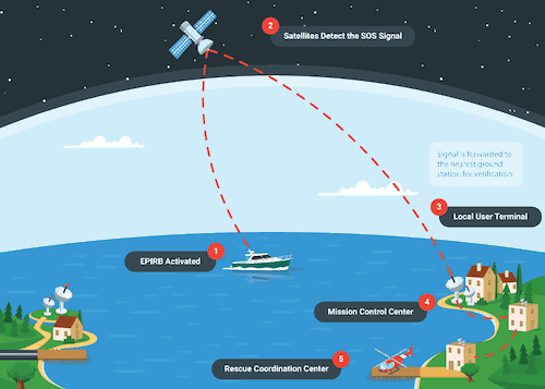
- When a locator beacon is activated it transmits an SOS message on the 406 MHz frequency (which is reserved for emergency distress communications) to the Cospas-Sarsat international search and rescue satellite constellation, and other geostationary satellites.
- The distress signal is then relayed to a network of ground stations and the U. S. Mission Control Center (USMCC) in Suitland, MD.
- Once alerted, the USMCC alerts the appropriate local or national authorities to initiate a search and rescue mission.
- Commonly, the very first thing the authorities will do is attempt to contact the beacon owner and/or his or her emergency contacts to make sure that it hasn’t been triggered accidentally, but assuming it hasn’t, rescuers can initiate a response within minutes.
In the past, the search and rescue personnel would have had a general location and homing in on the exact location of the beacon could take hours, as opposed to minutes.
Today, however, modern EPIRB and PLB models generally have internal GPS (sometimes people call them “GPIRBs”).
This allows them to transmit their exact location when activated, radically reducing the search-time. In fact, many mariners are fond of saying that a modern GPS-equipped EPIRB or PLB takes the “search” out of “search and rescue.”
By law, all locator beacons are registered with the National Oceanic and Atmospheric Administration (NOAA).
Once registered the beacon’s unique 15-digit identification code is then associated with either your boat or you personally, so if it ever gets triggered and begins transmitting its signal the authorities immediately know who you are, the size and type of boat the unit may be associated with, and additional information such as your port of call and emergency contacts