WIND STRENGTH AND BAROMETRIC PRESSURE
Good hurricane maps also may give other important information, such as forecasted wind strength. Not only is the wind strength number important for the hurricane’s eye wall, it’s also important in the areas around the eye. For instance, if you’re expected to be in the northeast quadrant of the storm’s direction of travel, you can probably expect greater wind strength than if you were to the west of the storm.
In addition to wind strength, information on barometric pressure may be given. The lower the pressure, the worse the storm. Also, a very low barometric pressure may mean a higher rise of the ocean. A trend up in barometric pressure is good news, but don’t let your guard down; all of this often changes. This is why you can’t just take a look at the map on Monday and forget about it the rest of the week. Not all maps show complete data; some are produced to show only the more basic data.
AM I SAFE?
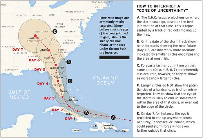
Many boat owners wait until it’s too late to take action, erroneously thinking that if they’re outside the cone they’ll be safe.
“If there’s one thing boaters need to learn, it’s that hurricanes can be unpredictable,” says Mike McCook of the BoatUS Marine Insurance Catastrophe Team.
Back in 2012, in the case of Sandy, many of the forecasts showed the storm heading out into the Atlantic. Instead, the storm tracked west and made landfall in New Jersey, catching boat owners off guard with devastating results.”
High winds, rain, and storm surge are just a few of the common phenomena that may affect boaters hundreds of miles from the actual center of a hurricane. Learning to read these maps accurately will give boaters a better idea when to take decisive action to protect their boats and property earlier, and with less panic, when a storm is forecast.